


Dataset
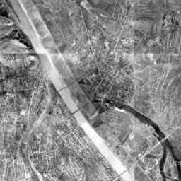
Luftbildplan 1956 Wien
| Maintainer | Magistrat Wien - Magistratsabteilung 41 - Stadtvermessung |
|---|---|
| Maintainer Link | https://www.wien.gv.at/kontakte/ma41/index.html |
| Maintainer Email | ogd@ma41.wien.gv.at |
| Publisher | Stadt Wien |
| Publisher Link | https://digitales.wien.gv.at |
| Publisher Email | open@post.wien.gv.at |
| License | Creative Commons Namensnennung 4.0 International (CC BY 4.0) |
| License Citation |
Datenquelle: Stadt Wien - https://data.wien.gv.at |
| Terms URL | https://data.wien.gv.at/nutzungsbedingungen |
| Metadata Link | https://www.data.gv.at/infos/geowebservices-potenzial-besser-nutzen/ |
| Geographic Toponym | Wien |
| Geographic Bounding Box | WGS84: POLYGON ((16.577511 48.322571, 16.18218 48.117668)) |
| Beginning Date/Time | January 1, 1955, 01:00 (+0100) |
| Update Frequency | nach Bedarf |
| Lineage Quality | Luftbildbefliegung 1956, Auflösung 15 cm, https://www.wien.gv.at/stadtentwicklung/stadtvermessung/geodaten/orthofoto/index.html |
| Schema Name | OGD Austria Metadata 2.6 |
| Schema Language | ger |
| Schema Characterset | utf8 |
| Resource title and description in English | The Vienna aerial image catalogue from the year 1956 covers the entire city area with a pixel size of 50 centimetres. The aerial images were taken in April 1956. <a href="https://www.wien.gv.at/stadtentwicklung/stadtvermessung/service/luftarchiv.html">https://www.wien.gv.at/stadtentwicklung/stadtvermessung/service/luftarchiv.html</a> |
| ID | d025f670-5719-417e-8750-07b9178e7d92 |
| Human readable URL | https://www.data.gv.at/katalog/en/dataset/stadt-wien_luftbildplanwien1956 |
-
Details
Field Value Data last updated December 15, 2015 Metadata last updated October 15, 2024 Data Format HTML License Creative Commons Namensnennung 4.0 International (CC BY 4.0) Data Identifier 308b9b70-9eb0-47c1-8237-9ee04308886b Metadata Identifier d025f670-5719-417e-8750-07b9178e7d92 Data URL https://www.wien.gv.at/ma41datenviewer/public/start.aspx -
Details
Field Value Data last updated December 15, 2015 Metadata last updated October 15, 2024 Data Format JPEG License Creative Commons Namensnennung 4.0 International (CC BY 4.0) Data Identifier a96ee1ed-c638-4a7d-a0d0-b38d824aea41 Metadata Identifier d025f670-5719-417e-8750-07b9178e7d92 Data URL https://www.wien.gv.at/ma41datenviewer/downloads/geodaten/lb_img/35_4_lb1956.zip -
Details
Field Value Data last updated April 1, 2016 Metadata last updated October 15, 2024 Data Format JPEG License Creative Commons Namensnennung 4.0 International (CC BY 4.0) Data Identifier 9806ee98-00f4-432f-9c22-e5926de56cf9 Metadata Identifier d025f670-5719-417e-8750-07b9178e7d92 Data URL https://mapsneu.wien.gv.at/wmts/lb1956/grau/google3857/12/1419/2234.jpeg -
Details
Field Value Data last updated April 1, 2016 Metadata last updated October 15, 2024 Data Format wmst License Creative Commons Namensnennung 4.0 International (CC BY 4.0) Data Identifier 330b5458-8338-41c6-9da9-4954545e1d79 Metadata Identifier d025f670-5719-417e-8750-07b9178e7d92 Data URL https://mapsneu.wien.gv.at/wmtsneu/1.0.0/WMTSCapabilities.xml